Saturday, June 24, 2006
Day 5 June 23 Prineville to John Day, OR


THE MONSTER DAY ...TURNED OUT OK!
(note: Our group was unable to get internet access last night. I will always attempt to catch up the following day)
We departed Prineville at 5:45 am this morning...the day I had termed a "monster day". Many of us ate in our rooms at 5:00 so that we would not be delayed at a restaurant breakfast. It was going to be a long and challenging day on the road. Many former AA-N cyclists and the staff said that this may be the most difficult day of our journey.
The route to John Day,OR was 117 miles East on route 26. Our bike computers recorded 5989 feet of climbing on today's ride. This combination of distance plus elevation gain over the course of the day was a real test for all of us. I was on the road for 10 hours today, finally arriving at our hotel destination at 4:00 pm. We are all tired , proud of our accomplishment and getting ready for whatever tomorrow may bring.
It was as tough a ride as we expected and as challenging a ride as I have ever done. However, It was more scenic and captivating I think, than any of us envisioned. It was an absolutely beautiful course through mountains, forests, rock canyons, along river banks, past ranches, and farms....all on a gorgeous sunny day. Oregon has such a variety of scenic beauty. Our cameas were as busy as our legs on this day. This ride was one for the books!
It was very cold leaving Prineville heading into the mountains and hot in John Day when we arrived. The terrain and vegetation changed several times as we climbed and descended our way through Central Oregon.
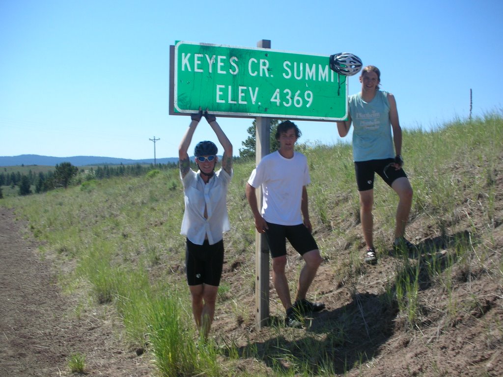
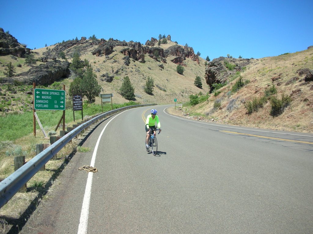
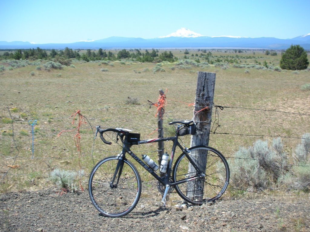
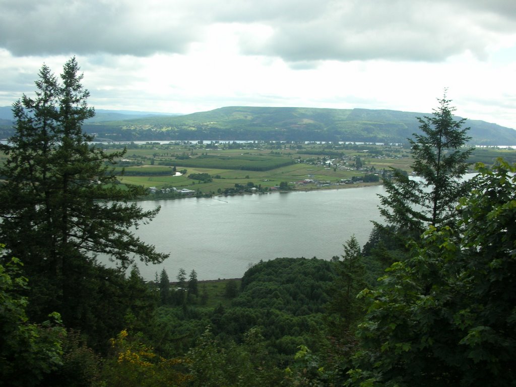
In the Ochoco Natoinal Forest we climbed for 15 miles to the summit of Mt Ochoco at 4720 feet. The 12 mile descent was described as: incredible, fabulous, terrific, and fun by fellow cyclists. We had returned to arid conditions with sagebrush and smaller trees amid the small cattle ranches. It is interesting to follow the changes in geology and vegetation as we ride through this region.
The high bluffs and rock formations we observed as we rode through the canyons were picture post card perfect. We biked into "Picture Gorge", which was well named.
It was a cycling day we will all remember fondly for its scenic beauty, and proudly for what we experienced and had accomplished.
Bill
Thursday, June 22, 2006
Day 4 June 22 Kah-nee-ta to Prineville,OR

BIKING IN CENTRAL OREGON
We departed the resort at 7:30 am in warm sunshine. The weather was a bonus on today's 61
mile ride to Prineville, OR. It was a shorter ride than normal, but we has some climbing -3900 feet- that gave us a challenge. The scenery was again remarkable and varied as we biked up and out of the box canyon from the Indian Reservation and into the small towns, farmlands, and grassy mesas of central Oregon.
We immediately encountered the first of several herds of horses roaming freely on the open range. They crossed the road in front of us and stood quietly for our cameras. Way up in the hills we saw a larger herd galloping to what must have been better grazing lands. Yesterday some cyclists suddenly came upon cattle in the road near the resort, nearly hitting them. They are restricted only by some cattle guards in the roads, which we find "jarring" when crossed on a bike.
Many of us stopped in the town of Warm Springs to tour the Indian Museum there. It showcased the history of the local tribes: the Wasco, Sahaptin, and the Pieutes. All were nomadic tribes whose main food sources were salmon, roots and berries. They moved from one location to the next to gather these food items. Three thousand Indians reside on this large reservation today.
Leaving Warm Springs and biking along side the DesShutes River with high bluffs forming a deep river valley, we watched fly fishermen standing in the rapid current trying their skills. It was a very calm setting.
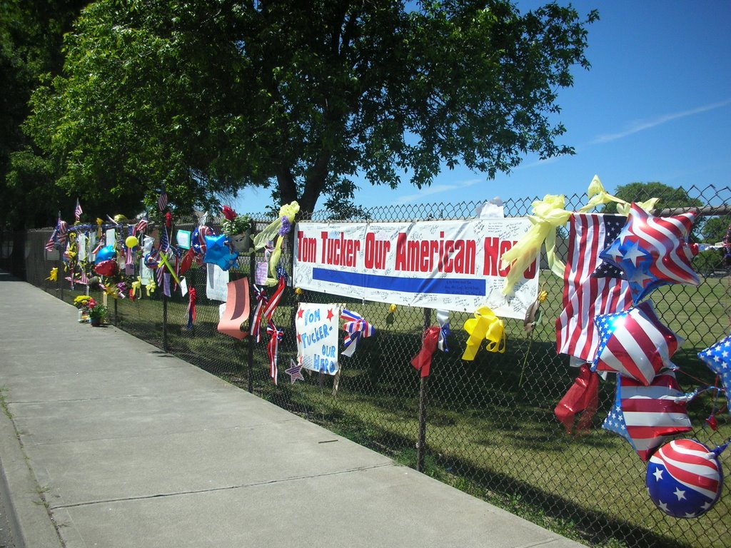
We reached the saddened town of Madras at the half way point of our ride today. The trees were tied with yellow ribbons and American flags were placed beside them. The signs on banks and in store windows offered prayers and thanks to their brave soldier's family. Madras is the hometown of Pfc Thomas Tucker, one of the two soldiers recently captured and killed in Iraq. A candlelight memorial is planned for Friday night in Friendship Park-- where our SAG stop was held today.
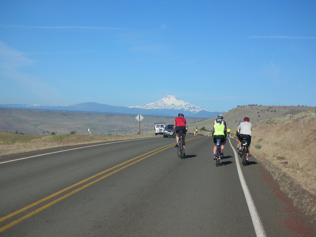
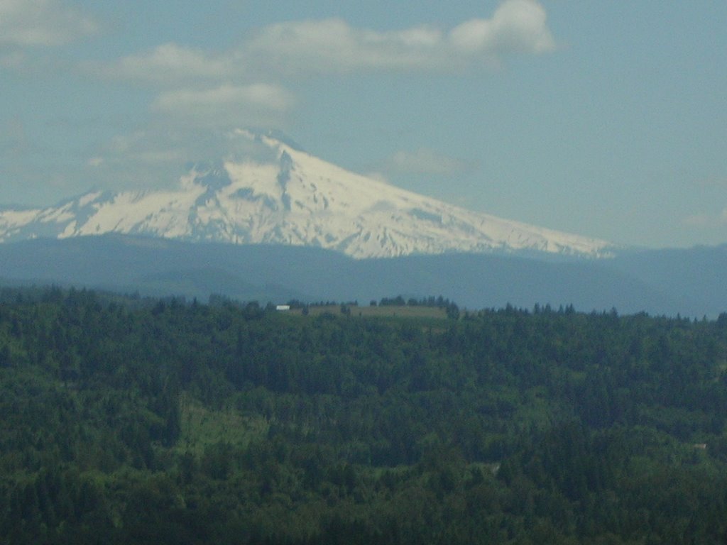
This arid region of central Oregon has irrigated farmlands which we rode past. Our concensus opinion of the major crop we saw was OATS. My non-farm cycling companions and I later learned it was ALFALFA. We saw many other crops later in the ride ....but none of us ventured a guess as to what we were seeing. We did confirm that it was Mt Jefferson that we could see in the background of these fields.
An area designated "US National Grasslands" was next along our route. Barren, desolate land was all we could see for many miles. In the last 20 miles we had some great flats and some descents, so we let it rip into Prineville, our destination.
Tomorrow is a MONSTER DAY!.....117 miles with 5500 feet of climbing. We'll be on the road by 5:45 am. I guess I'll miss the Crooked River Rodeo scheduled for tomorrow night in Prineville. Oh well, the life of a cyclist.
Bill
Wednesday, June 21, 2006
Day 3 June 21 Welches to Kah-nee-ta,OR

CLIMBING THE CASCADES
ABB mentioned at route rap that this would be a difficult climb day. At 6:40 am we began the 66 mile up route 26 to Kah-nee-ta, OR through the Cascade Mountains.
I was a bit apprehensive about today's ride. The instruction sheet said "go .8 mi from the hotel, turn right---Get Ready To Climb!" The first climb of the day was the longest climb at 11 miles with an average 5% grade and an elevation gain of 2500 feet. It was a cold morning, in the 40's, but we were dressed warmly in jackets, windbreakers, leg warmers etc., knowing that the descents would be very cold. We climbed slowly and steadily into the low clouds to the top. ABB had set up a SAG stop there in the Mt Hood National Forest. Everything I was wearing was wet from perspiration---it was cold.
At this 13 mile mark the route sheet read: "Now descend 1000 feet in 4 miles, then climb 1000 feet in 3 miles. At the 27 mile marker climb 800 feet in 3 miles. At 30.5 mile marker road gets narrow and desolate--you will descend 1500 feet in the next 10 miles". This was our up-and-down ride through the Cascade Mts of Oregon. It was an unforgettable experience. The old growth forest of hemlock and spruce is majestic, the air is fresh and cool, the adventure and the challenges are PRICELESS.
At several points we looked back in our rear view mirrors and saw the massive Mt Hood dominating the landscape, but getting smaller as we continued our trek East.
In all the miles of exciting down hill runs that followed the climbs today, the environment changed. The terrain became flatter, the trees were now smaller and more sparse, the grasses had turned brown and the temperature rose. In a matter of 20 miles we had gone from the steep mountain forests to the high desert of Oregon. We could now see clearly off in the distance the range of snow covered mountains which includes "the Presidents": Mt Adams, Mt Jefferson etc. They were visible as we looked across a parched sagebrush landscape at the side of the road. A complete transition of climate and scenery in such a short period of time.
After the SAG at mile 45 we turned onto route 3 and headed to the Indian Reservation near the town of Simnasko where our hotel, the Kah-nee-ta Resort, is located. These last 20 miles of the day provided as much fun as one can have on a bike. The high desert landscape was hilly, dry, sparse, rocky....beautiful. The terrain rolled up and down the box canyon to the resort. We had a 30-40 mph descent for 3 or 4 miles to the base of the canyon.....cut backs, S-turns, through high rock bluffs close to the road at fast speeds. It was a high....terrific!
The resort is spectacular: pools, a golf course, casino, etc with expansive views of the dry hills in the distance. Many bikers took to the pool for a relaxing afternoon.
Another great day on the road.
Bill
Tuesday, June 20, 2006
Day 2 June 20 St Helens to Welches, OR

There was complete agreement about today's 75 mile ride to Welches, OR; everyone loved it! It was a great day on the bike! The route was varied and interesting, the scenery was stunning, and the weather was ideal for cycling; clear and cool. We had a few climbs (2900 ft of climbing today) and some fast descents. We crossed over the Willamette River on the St John's Bridge, and rode on an off-road bicycle path along the Columbia River for many miles.
It was appropriate that "Team RTC" suited up in our Rails-to- Trails jerseys today, as we experienced the safety and pleasure of biking on the scenic pedestrian-only bike path in North Portland, OR. Part of the ride was on the levee of the Columbia River where we passed by the airport in small groups enjoying the great pathway provided for bikers and pedestrian recreation.
It was in the town of Orient, OR that we got our first view of Mt Hood....WHOA! There it was --the massive snow covered mountain we had all been waiting to see. We had many more sightings as we rode on route 26 heading directly at it. It REQUIRED you to get off the bike and take another photo. It is a beautiful sight. Skiers and snowboarders are still on the mountain for summer training on the glacier.
The region near the mountain that we rode through today is a center for large commercial nurseries covering hundreds of acres of trees in various stages of growth. The seedlings and young trees of all types are grown here to supply local nurseries around the country.
Our hotel tonight is The Resort at the Mountain (Mt Hood), which is a first class resort with all the ammenities. It is located in a peaceful forest park setting in the Cascades. ABB has informed us that we should not get accustomed to such luxury--we have a long way to go--and a lot more Super 8's.
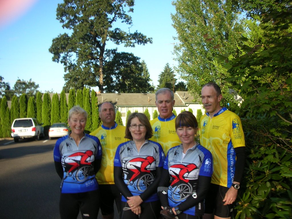
We have a mom and her 2 teenage sons with us on the trip. They ride a TRIPLE bike, a bicycle built for three! They are perhaps the fastest bike in the group (6 legs make it fly). The family has lived in Paris, France for the past 10 years, where the boys go to French schools. They have absolutely no accent in either language. (I'll have to try out my language skills.) All three were in University of Notre Dame biking outfits today as the father and grandfather are alumni. Mom said to me with a wink, "There is absolutely no pressure on the boys". It is an interesting group we have here.
Tomorrow is guaranteed to be a "tough day". I'll give you a report.
Bill
Monday, June 19, 2006
Day 1 June 19 Astoria to St Helens, OR
 Note; Please check yesterday's blog for Photos added.
This morning at 6:30 am sharp the full contingent of 64 ABB cyclists and staff jammed into the breakfast "nook" of the Best Western. The lone server had her hands full trying to keep the continental breakfast buffet table stocked with sufficient food items. We all ate, loaded our luggage onto the "box truck", and went out to the patio for a group photo on the bank of the Columbia River.
We departed smartly attired in our new ABB red, white and blue jerseys on a 69 mile trek from Astoria to St Helens, OR. The trip was entirely on route 30, "the old Oregon trail"and the path of the Lewis and Clark expedition to the Pacific. It was chilly and somewhat cloudy all day as we biked along side the Columbia River. We has 2 significant climbs today, but the total elevation gain was only some 3000 ft. In just a few days we will be facing several major climb days in the Cascades. This was an excellent "opening day" ride.
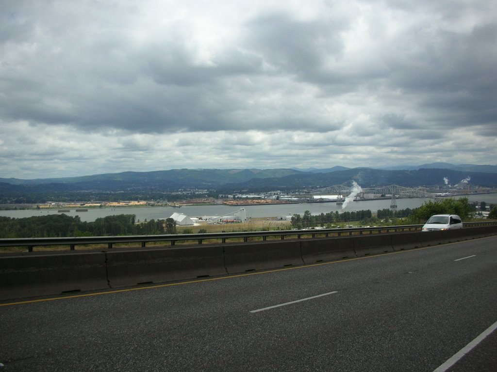
Numerous logging trucks passed us along our route. We are in the heart of pulp and paper country. The familiar odors emanating from the mills, and the sight of these smoke stacks and wood chip piles brought back memories of my many years in the industry. A photo shows the large mill complex at Longview, WA across the river from our route.
Our first SAG stop at mile 22 (see photo) was in a beautiful park setting high on a cliff overlooking the river and the mountains of Washington in the distance. I began my "eat healthier routine" at the SAG. Instead of my former standard snack of 10 Oreo cookies, I had a banana, an orange, mixed nuts, a fig newton and gatorade. I have not yet noticed a marked improvement in my riding. (Maybe I'll go back to the Oreos).
You meet remarkable people on these trips. Today riding into the SAG I talked to Don (MA) and Mike (Scotland). Don has completed 2 IronMen, 50+ marathons and 5 one hundred mile runs in under 30 hours. Incredible! Several people in their introductory comments mentioned that a long-time goal was to ride a bicycle across America. Mike said his goal was "to ride a bike AROUND THE WORLD ! He has completed the perimeter ride around Australia, the tour of Africa, and is underway across America. He plans to ride Beijing to Istanbul next. Amazing!
After a lunch stop at Richmond's Country Kitchen in Ranier, OR, we kicked up the pace for the final 20 miles into St Helens. We were told that on a clear day one can see Mt St Helens, Mt Adams, Mr Ranier and Mt Hood from this paper mill town of 10 thousand people. We are hoping for one of those clear days tomorrow.
Bill

Sunday, June 18, 2006
Day 0 June 18 The Oregon Coast and Orientation

Never one to arrive anywhere LATE, and wanting a few days to acclimate, I arrived in Portland, OR on Wednesday night June 15, four days before the start of our cross country bike ride. With plenty of time to adjust to the time difference and cooler temperatures, there was also the opportunity to tour Portland, drive down the beautiful Oregon Coast, and prepare my bike (and my focus) for the ride.
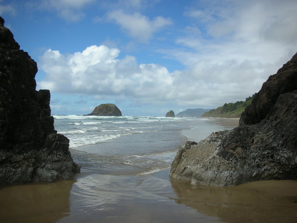
Gray skies and green landscapes are the mark of the Pacific Northwest. Traveling south from Astoria to Seaside to Cannon Beach along route 101, Oregon's scenic coastal highway, we saw plenty of both. The shoreline is stunningly beautiful.
Just south of Seaside, Joyce and I visited Ecola State Park at Tillamook Head with its trails and viewpoints along 9 miles of incredible cliffside shoreline. It is part of the Lewis and Clark National Historic Trail . In fact, William Clark and Sacajawea came to this beach in 1806 in search of a beached whale. A park ranger informed us of the bird species that colonize the offshore rocks here: gulls, pelicans, puffins, and a colony of several hundred common meers, a small penquin look-alike which we observed nesting on the rocks. The forest landscape leading into the park was filled with majestic Western hemlock and giant Douglas fir trees growing from a forest floor of lush green ferns. This region is truly a scenic part of the American landscape, confirmed by the large numbers of tourists we saw.
The Holiday Inn Astoria is situated below the 4 mile bridge over the Columbia River into Washington State (Where " sleeping under the bridge is a GOOD thing", according to the sign out front). It is" home "to 56 cyclists and 6 ABB staff members gathering for the Across America-North ride.
My first take at some interesting statistics on the 2006 AA-N:
46 cyclists "going all the way"
10 part way riders starting in Astoria, OR
A total of 56 riders from 17 States and France, Germany, England, Scotland, Wales, and Switzerland.
4 married couples
11 women in all
About 20 riders in "my age group of 60 +/-"
Wow, what a group!
Yesterday we had a mini reunion of 2004 Cross Country Challenge riders and staff members. Our ABB leaders from that tour, Michelle and Andy, are back with us. Also from 2004 CCC we have Dan, Joyce, Tim and Kathryn and Dale. Jerry Meenk and his wife drove down from Seattle to have dinner with us last night. It is great to be with the old gang again!
As "experienced alumni", we were asked to lead the contingent of riders to today's tire dipping ceremony in the Pacific Ocean. We formed up at noon and headed to Shipwreck beach in Ft Stevens State Park about 12 miles from Astoria. We carried our bikes down to the water's edge where we touched the rear tire in the Pacific, symbolizing the start of our ocean to ocean adventure.
The orientation session covering rules, safety, rider introductions, bike mechanics etc took the better part of this afternoon and evening. Our diverse and large group is prepped and ready to go. Bring it on!
![]()
